

Colombia Tests New Technology to Respond to Emergencies in Remote Areas
Colombia successfully tested D2D satellite technology, allowing remote smartphones to send life-saving SOS messages without cellular coverage.
Explore how geosynchronous and geostationary satellites function, the adjustments needed for efficient transmission, and the crucial role ephemeris data plays in predicting satellite positioning.


Your cell phone was designed to connect with cell towers within a two to five km radius. At Skylo, we’re connecting that same cellular hardware over satellites that are up to 36,000 km away. To accomplish this requires incredible precision in timing to account for the large distances that signals must travel. Also, your cell tower isn’t moving at upwards of 6,000 mph. We have to therefore also account for the shift in frequencies that occur when a signal source is moving at those high speeds, referred to as ‘doppler.’ To accomplish all this, we need to know precisely where the satellite is at any given moment in time that we want to ‘bounce’ our cell signal off of. Doing so requires a surgical level of accuracy which accommodates standard cellular protocols without requiring any specialized hardware or antennas.
In this blog, we take a look at the differences between geosynchronous and geostationary satellites and the special considerations needed to ensure clean, clear, and efficient communications.
While there are many types of satellites, they are often categorized by the distance from the earth in which they will orbit. Here’s a brief overview of each of those three orbits. See Figure 1.
Low Earth orbit (LEO) is the lowest orbit to the Earth, typically not exceeding 2,000km. Satellites in this orbit are commonly used for imaging of the Earth’s surface and communications. Because a typical LEO satellite is in view for only several minutes, devices using them must be “handed-over” from one LEO satellite to another LEO satellite for maintaining continuous communication.
Medium Earth orbit (MEO) satellites fly in the orbit between that of the LEO and Geostationary orbit (GEO) satellites.
GEO is approximately 36,000km above Earth and the satellites that typically reside here are positioned over the equator. GEO satellites rotate around the world at the same rate as the Earth’s rotation, so they appear to stay in a fixed position. The coverage area of a single GEO satellite is quite large, requiring three of them to cover the majority of the Earth’s surface.

“Geosynchronous” and “geostationary” are two terms commonly associated with satellite orbits. Though often used interchangeably, these terms refer to distinct orbital characteristics that influence a satellite’s functionalities and applications.
A geosynchronous satellite orbits the Earth at the same rotational speed as the planet. Consequently, it completes one full orbit in approximately 24 hours, maintaining a constant position relative to the Earth's surface. It is important to note that while geosynchronous orbits are possible at other inclinations, geosynchronous satellites are usually positioned around the equatorial plane. See Figure 2 for an orbit comparison.
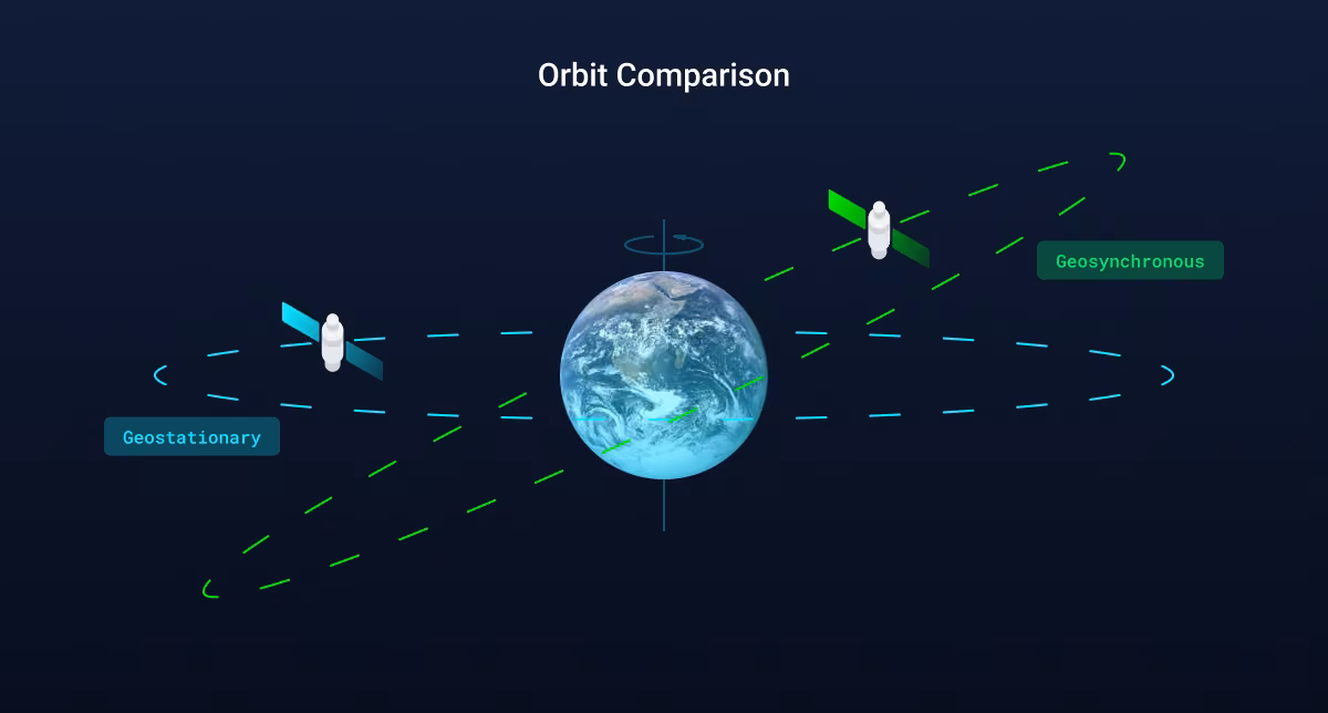
Geostationary satellites are a subset of geosynchronous satellites. They have the same 24-hour orbital period as geosynchronous satellites, but they also have an additional characteristic - they must be positioned directly above the Earth's equator. By being placed in this specific position, these satellites appear motionless when observed from the Earth's surface, effectively "stationary."
While geostationary satellites remain stationary with respect to the Earth's surface, geosynchronous satellites follow an intriguing figure-eight pattern over a 24-hour period (Figure 3). This movement is called a lissajous pattern, caused by a daily north-south movement induced by the gravity of the moon and sun, and becomes more pronounced with each passing day. Satellites use thrusters to prevent this motion from exceeding the pointing requirements to maintain the same coverage footprint. The pattern variation leads to continuous changes in the delay and doppler effects experienced by signals transmitted to and from these satellites. We explain this further later on this blog.
.gif)
Non-terrestrial networks (NTN) operate very differently than terrestrial (cellular) networks in a variety of ways, but one of the biggest differences is the timing adjustments that must be made to ensure that signals are delivered efficiently and reliably. The distance a signal must travel roundtrip from device/transmitter/origin to satellite is nearly 72,000km (36,000 km up to the satellite, and 36,000 km back down to the ground station). During this transmission, there are natural occurrences that can delay or disrupt its delivery, compromising signal quality. This is called the Doppler Effect, when the wavelength of a transmission, either sound or radio, is changed, due to either the position of the sender or that of the receiver moving. This results in the received frequency differing from what was originally sent.
To overcome these effects effectively, we need an accurate, realtime picture of exactly where the satellites are. The ‘roster’ of satellite location data is known as ‘ephemeris’. Ephemeris, (pronounced, uh·feh·mr·uhs), is defined as the predicted or calculated positions of a satellite, planet, or comet in space over a specific period of time. Ephemeris is derived from the Greek word "ephēmeros" ("daily"), historically referring to a set of astronomical data that describes the positions and velocities of celestial objects at specific times. In fact, you use ephemeris data all the time in your daily lives. When you use GPS to navigate, your phone uses satellite ephemeris data combined with timing signals from the GPS satellites to triangulate its relative location in 3D space.
Compensation for the situations we discussed requires a continuous ephemeris broadcast by the original sender (in the case of a GEO satellite, a base station) with timing and doppler correction by the device to maintain an efficient connection.
The current industry standard solution is designed for short, sporadic data transmission only. Maintaining the precise position of a geosynchronous satellite requires accurate tracking and prediction of its orbital path. Ephemeris data plays a critical role in achieving this.
In the context of geosynchronous satellites, ephemeris data provides information about the satellite's position, velocity, and acceleration relative to Earth. Ephemeris data enables scientists and engineers to calculate a satellite's orbital elements, such as longitude, inclination, and eccentricity, all crucial to predicting its future positions accurately.
Ephemeris data is typically generated through a combination of ground-based observations and computational models. Observatories, tracking stations, and radar systems around the world continuously monitor satellites, collecting data on their positions and movements. These data are then used to refine computational models that generate ephemeris data.
Organizations such as NASA, the European Space Agency (ESA), and the International GNSS Service (IGS) are at the forefront of collecting and disseminating ephemeris data. They provide access to precise and up-to-date information, allowing satellite operators, scientists, and researchers to make accurate predictions and maintain the required accuracy in satellite positioning.
Achieving precise timing becomes paramount as even minor deviations can result in disruptions and compromised connectivity. With over 82 patents, five of these related directly to doppler and timing synchronization, Skylo’s proprietary technology and its Standards Plus approach enables nanosecond-level accuracy and ephemeris and timing adjustment model updates. This allows devices to remain in a connected state for a longer period of time, providing continuous timing updates, supporting continuous data transmission, and longer text messaging sessions.
By mitigating the impact of changing delay and doppler effects, Skylo ensures reliable and uninterrupted connectivity. Unlike conventional solutions, Skylo enables longer messaging sessions and supports continuous data transmission, allowing for enhanced efficiency and improved user experiences.
Let’s take a look at a real-world example of how Skylo uses ephemeris data to optimize signals sent to geosynchronous satellites.
First, we’ll walk through a scenario showing the position and path of three satellites as seen from the surface of Earth (Figure 4):
Inclination refers to the angle between the satellite's orbital plane and the equatorial plane of the Earth. In our example, Satellite_5 and Satellite_10 have an inclination that is not 0° (i.e., its orbital plane is tilted relative to the equatorial plane). This is because the satellite will still complete one orbit in 24 hours synchronously with the Earth's rotation, but it will drift north and south due to its inclined orbit.
Satellite_5 and Satellite_10 exhibit a figure-8 motion, whereas Satellite_0, which is positioned directly over the equator, stays stationary when observed from Earth.
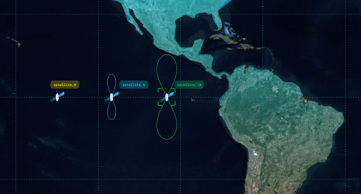
Second, let’s zoom in on Satellite_5 and Satellite_10 to see the figure-eight movement in Figure 3. It’s shown in three-dimension to demonstrate the Earth-Centered, Earth-Fixed (ECEF), which is a Cartesian coordinate system used to describe the position of a point or object on or near the Earth's surface using its X, Y, and Z coordinates relative to the Earth's center.
Next, let’s observe the impact of satellite motion relative to devices on the Earth.
Figure 5 shows a geostationary satellite network architecture. The wireless link between the satellite and the device is referred to as a service link. The link between satellite and base station is referred to as the feeder link.

The distance between a device on the Earth’s surface to a satellite and a satellite to a base station is referred to as 'one-way distance’ between the device and the base station. In this case one way distance is varying between 76,200 km to 77,900 km over the course of the day. This variation of 1,700 km has a tremendous implication on devices that need to be managed at the micro-second level. This also means that the word ‘stationary’ in geo-stationary is really a relative measurement as no GEO satellite in reality is geo-stationary but instead geo-synchronous. Figure 6 shows the relationship between time and the one-way distance over the course of a single day.

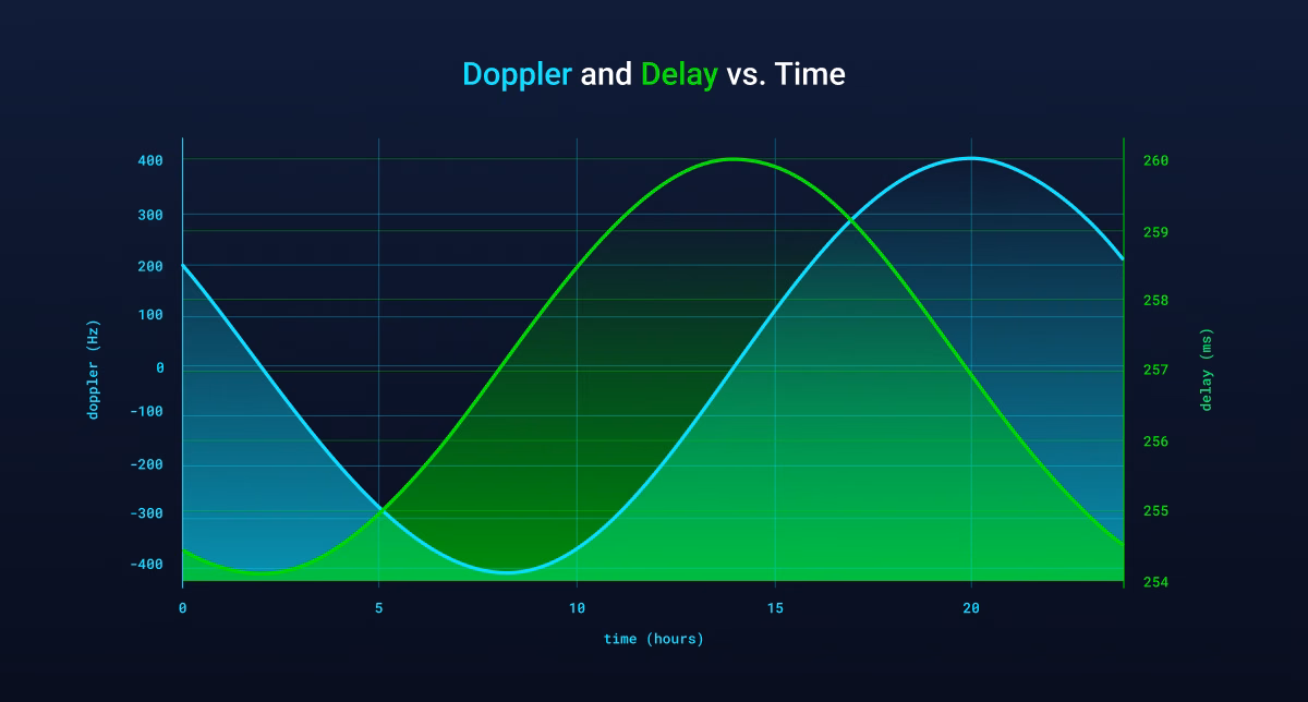
Figure 7 shows the variation of delay and doppler with time for a fixed UE location.
The time it takes for a wireless signal to travel from the device to the satellite and from the satellite to the Earth station is referred to as “one-way propagation delay.” Due to the continuous change in the satellite’s position relative to the device, devices experience a continuously varying propagation delay and doppler. Satellite motion impacts both the service link and the feeder link delay.
One-way Propagation Delay = (Service link delay) + (Feeder link delay)
Figure 7 shows the doppler due to the variation in service link delay alone. Usually, the doppler incurred by the feeder link delay is pre-compensated and is not observed by the device. Devices experience different doppler at different times of the day. In this particular case the doppler is varying between -400 Hz to 400 Hz.
During a period of 24 hours, the one-way-delay between satellite and base station can change by approximately six milliseconds (from ~254 msec to ~260 msec ). In order to maintain a proper communication link, the signal carrying the user data should arrive at the base station within a window of only a few microseconds. This requires nanosecond level accuracy in the ephemeris data broadcasted by network.
Thus, continuous timing and continuous doppler adjustment is required to maintain the connection for longer durations. Skylo’s network broadcasts high-accuracy ephemeris and timing adjustment models to enable timing correction by the device and hence maintains reliable connections at all times.
In the increasingly crowded satellite market, Skylo's emphasis on geosynchronous satellite technology sets it apart. By leveraging the unique capabilities of geosynchronous satellites, Skylo provides a superior solution for maintaining timing accuracy and ensuring seamless connectivity. This blog highlights the advantages of geosynchronous satellites over their geostationary and LEO counterparts, offering readers a comprehensive understanding of the benefits provided by Skylo's cutting-edge technology.
Geosynchronous satellites, though over the equatorial plane, present unique challenges in maintaining timing accuracy. Skylo's advanced timing solution addresses these challenges, enabling nanosecond-level accuracy and continuous connectivity. By leveraging the distinctive characteristics of geosynchronous satellites, Skylo delivers a robust and efficient communication solution. As we explore the future of satellite technology, it is clear that geosynchronous satellites and Skylo's innovative approach play a crucial role in advancing connectivity and data transmission capabilities.
Stay tuned for our upcoming blogs as we delve deeper into the fascinating world of satellite technology and its impact on various industries.
Interested in working at Skylo? Review jobs and apply here: jobs.skylo.tech.


.avif)
.avif)


.avif)


.avif)
.avif)
.avif)


.avif)


.avif)
.avif)

%204%20-%20high%20res.avif)


.png)

.png)
.png)
.avif)
%20(1).avif)
.avif)
.avif)
.avif)
.avif)
.avif)
.avif)
.png)

.png)

.avif)
.png)
.avif)

.png)
.avif)
.png)
.png)
.png)
.avif)
.png)